Overview

The vLoc3-DM is used to precisely locate pipelines and assist in evaluating pipe coating defects. The system can be used on either transmission or distribution systems. A complete ACVG survey can be undertaken using the vLoc3-DM and plug-in A-frame. The display on the vLoc3-DM has been configured specifically for pipeline evaluation. Data can be graphed in real-time on the receiver while still on site. The walk back feature highlights the operator’s position on the graph allowing them to return to the point of interest where further evaluation or an ACVG, A-frame survey can be undertaken.

With two sets of 3D antennas, signal distortion is easily detected and displayed on the bright full-color display. The vLoc3-DM introduces new locate perspective screens of Vector Locate for fully automatic non-walk over locating, Transverse Graph showing both peak and null simultaneously providing an immediate measurement of signal distortion, and Plan View showing the relative orientation of the cable at any angle. Visual and mechanical vibration alerts can also be configured by the user providing warnings for shallow depth, overload, overhead cables, and excessive swinging.

The 150-watt Loc-150Tx DM Transmitter typically applies the locate signal by connecting to the pipe at CP stations and test posts. The transmitter is designed to be powered from CP stations, AC or external batteries. Two rotary/push control knobs provide access to frequency selection, output level, menu information and active/standby modes. This transmitter is supplied with a direct connection lead, DC input lead and AC mains lead.

Key Features

  • Real-time on-screen mapping and data review
  • Identify the location of coating defects
  • Color-coded EM distortion warnings
  • Low-frequency 3Hz and 4Hz current mapping
  • Internal Bluetooth and GPS
  • Internal data logging
Downloads Save
vLoc3-DM Sales SheetPDF
vLoc3-DM Technical SpecificationsPDF
vLoc3-DM User HandbookPDF

MyLocator3 Software

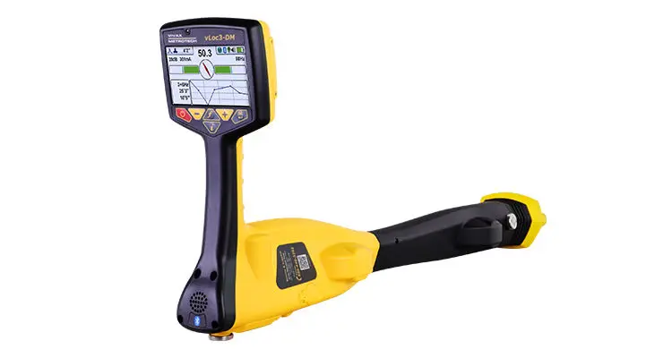
Manage a single or fleet of vLoc3 series utility locators with the free MyLocator3 app. Configure locators by turning on or off features, selecting which frequencies the user has access to and creating custom startup screens. When the locator is connected to a computer running the MyLocator3 software, the program will automatically search our database for the latest software for both the utility locator and desktop application. The utility locator connects to the computer running MyLocator3 by supplied USB cable.


  • Data transfer – MyLocator3 app will download the data collected from the locator including a timestamp, GPS coordinates, depth measurements, current on the line, and notes entered at the time of locate.
  • Software updates – MyLocator3 checks for locator software updates and app software updates whenever connected to internet.
  • Personalize – Add owner/user information, a background picture or logo, or a short message to the startup screen.
  • Lock Feature – The locator’s configurations and settings can be locked, enabling equipment or safety officers to ensure that features selected or removed by management cannot be over ridden by the user. (Requires optional lockout dongle)

VMMap App

When used with Bluetooth enabled Vivax-Metrotech receivers, the VMMap Utility Mapping app records data from the field which is instantly available online via the VMMap Cloud web portal or can be shared by using the email function in the app. Location data is obtained from the mobile phone, or an external GPS device of your choice. Depth readings, GPS coordinates, the distance between locates and more are captured as data logs and can be saved as xls, txt, shp, and kml extension files. The data is compatible with Google Maps, Asset Management, and GIS software.

The image capture feature in the app allows the user to attach a JPEG format image to the surveys. This is useful to add points of interest or a snapshot of the completed survey. Access the image files and all the data captured in the app in the VMMap Cloud web portal or email it from within the app.

The VMMap app generates maps in real time, giving confidence to the field technician that the data being collected is accurate.


  • Uses both Google and Apple Maps
  • Low and high GPS accuracy settings
  • Plug-and-play Bluetooth pairing to receivers
  • Export to various file types for use with popular GIS programs
  • Compatible with Google Maps, Asset Management, and GIS software
  • Show multiple utilities on one map with color-coded utility drop pins
  • The VMMap Mobile application is compatible with both iOS and Android devices.


Get it on Google Play

© Copyright 2020 RDG Supply Sdn. Bhd. - All Rights Reserved